- Author
- Torrington, Reg
- Subjects
- History - general
- Tags
-
- RAN Ships
- None noted.
- Publication
- December 1999 edition of the Naval Historical Review (all rights reserved)
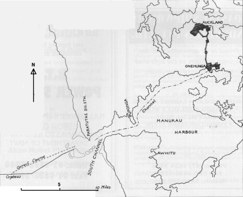
He was then ordered to proceed to New Zealand to join HM Ships Niger and Harrier stationed at Onehunga in Manukau Harbour, and to assist in quelling the Maori uprisings in the Colony. Prior to departure, a number of Australian midshipmen were added to the ship’s complement. The ship sailed from Sydney at 1600 on the 31st January, 1863. After a calm and uneventful voyage of seven days, the New Zealand west coast was sighted about 0700 on Saturday morning, 7th February. About 1230, the ship was readied for entering harbour as it neared Manukau Harbour. The Port of Onehunga lay twenty miles from the Manukau Heads.
Then something very unusual occurred. A sailor, Frederick Butler who had deserted his ship in Sydney, had been arrested and was being returned to New Zealand in the ship’s “brig”, noticed from his porthole that the ship was not on a correct course to enter harbour safely. Butler was familiar with this harbour as he had been quartermaster in HMS Harrier and had crossed the bar at the harbour entrance on two previous occasions. He called out and was taken to the Commodore on the bridge and told him that Orpheus should be steering a course more northerly to cross the bar safely and enter the main channel. Commodore Burnett showed Butler the chart. Butler cried out “It is the wrong chart!” again pointing to where the main channel lay. Commodore Burnett ordered the helm to be put hard to starboard and the engines reversed.
But it was too late and she struck the shoal, ploughed a short distance and then struck again with a heavy jolt that shook the whole ship. She went broadside on to the sea and was heavily pounded by the breaking waves. Boats were lowered; the launch overturned but the pinnace got clear.
As the afternoon wore on, the sea increased in intensity; people were swept overboard while some of those in the riggings on the masts decided to take a chance and jumped into the sea. Nearly all who did so were drowned.
As darkness fell, the masts started to go – first the main mast, then the foremast quickly followed by the mizzen, and the ship started to break up. By the next day nothing of the wreck remained. In all 189 died in this disaster, there being 69 survivors. Most of the bodies were washed ashore around the harbour, and buried in the sand dunes by the Maoris who had taken their frail canoes through heavy seas to rescue many of the survivors.
The body of Commodore Burnett was washed on to Waitakeri Beach nearly two weeks after the disaster. He was buried at Grafton Bridge Cemetery in Auckland, after a State funeral, on the 23rd February, 1863.
The first chart of this harbour was prepared in 1853 on a survey carried out by Captain Drury in HM surveying vessel Pandora. Then in 1861 a new survey, ordered by the New Zealand Government, was carried out. From this survey a new code of signals and revised directions for entering the harbour were officially published in the Government Gazette of 21st August 1861.
Contained in the new directions the following unmistakable warning:
“…the outer south bank has worked northward three-quarters of a point in the bearing from Paratutai and part of the north bank has cleared away since it was first surveyed by Captain Drury of HM surveying vessel, Pandora in 1853.
The directions for crossing the bar in that survey (the 1853) will lead over shallow and dangerous water.
The course now to be steered is north east by east three quarters east, the Ninepin Rock full breadth open to the southward of the Paratutai.
So in effect the bar and main channel has shifted north in the intervening eight years between the two surveys.“
Orpheus had the 1853 chart and Veitch’s Sailing Directions which were based on the Captain Drury survey and so did not contain the 1861 information. Butler, who was one of the survivors, confirmed that the 1853 chart was being used.
Investigation into the loss of HMS Orpheus began on the 9th February, 1863 with an enquiry in HMS Miranda at Auckland before the Hon. A. Domett, Colonial Secretary, and others. This was quite unsatisfactory and evidence was given reluctantly and with considerable disagreement between the witnesses who were clearly ill-at-ease. The First Lieutenant of Miranda eventually stopped the enquiry, on the grounds that it was contrary to the regulations of the Service to hold an official investigation on board a man-of-war unless the senior officer of the ship is present. The enquiry was inconclusive.