
The following summarises a presentation given to the Sydney Branch of the Company of Master Mariners and Australian Institute of Navigation & The Nautical Institute South East Australia Branch first published in The Megaphone, September 2019. It is reproduced here courtesy of the Company of Master Mariners.
The address was given by Professor Chris Rizos, Emeritus Professor School of Civil & Environmental Engineering UNSW. Chris Rizos is also a co-director of the Satellite Navigation and Positioning (SNAP) Lab at UNSW. Chris is a former President of the AIN.
GNSS stands for Global Navigation Satellite System, and is the standard generic term for satellite navigation systems that provide autonomous geo-spatial positioning with global coverage. This term includes e.g. the GPS, GLONASS, Galileo, Beidou and other regional systems[i].
What is the difference between GNSS and GPS?
GNSS and GPS work together, but the main difference between GPS and GNSS is that GNSS compatible equipment can use navigational satellites from other networks beyond the GPS system, and more satellites means increased receiver accuracy and reliability.
GNSS is nowadays an indispensable technology of our modern society. It can be used for all professional navigation, surveying and positioning applications in outdoor environments. GNSS is embedded in many smartphone applications, and it is poised to be used for future automated navigation systems on land, in the air and at sea.
Until recently lower levels of accuracy had been acceptable. However, now in many industries greater precision is imperative, such as in vehicle automation. For example, positioning in vehicles is going from ‘passive’ to ‘active’ levels of autonomy, with passive providing a backup to a human primarily in control, and ‘active’ for (near) full autonomy of operation. This passive to active range includes supporting simple navigation to information about traffic to warnings about hazards to actively avoiding hazards to enabling autonomous operations.
Multi-satellite constellations ensure that a number of satellites are visible at any one time on any location on Earth, together with multi-constellation capable receivers provide at least part of the answer for improved accuracy and assuredness. The rise of Space Based Augmentation Systems (SBAS) around the globe is also a partial answer to providing GNSS assurance. SBAS offer improved positioning accuracy (sub-metre) and also improved integrity – contributing to meeting the emerging requirements of many commercial users.
Prof Rizos noted that there are many inherent errors and inaccuracies that need to be considered when using GNSS. GNSS errors will be the result of errors introduced through routine operations of the satellite system, equipment malfunctions, environmental effects, and other factors. Some examples are:
- unannounced or unplanned manoeuvres of the satellites
- faulty clock, signal generator, or antenna positioning
- faulty broadcast messages
- atmospheric effects
- space weather (e.g. solar storms)
- ionospheric disturbances
- correction messages from SBAS
- loss of uplink communications
- software, and other, errors
- He noted that increasingly there are challenges to the integrity of the GNSS arising from interference, including: jamming, non-intentional (e.g. multipath, M-GNSS, out-of-bound emissions, etc)
- deception
- spoofing
- meaconing[ii]
Ships sailing in the Strait of Hormuz and the Persian Gulf have been experiencing GPS jamming that the US has attributed to deliberate jamming by Iran. An advisory was issued in August 2019 warning vessels of this GNSS jamming. In addition to GPS jamming, commercial vessels have reported bridge-to- bridge communications spoofing and other interference. It appears that Iran seeks to have non-Iranian vessels get off track and enter Iranian waters where they can be seized.
Summary
Prof Rizos concluded by noting that GNSS is a critical civilian infrastructure and a vital military capability. GNSS has been a remarkably reliable Positioning Navigation Timing technology, but satellite signals are very weak and can be disturbed. GNSS can suffer loss of availability or integrity functions due to natural causes or human actions. A new trend is an increasing prevalence of GNSS jamming & spoofing. There is an increasing need for trustworthy positioning within required navigation performance (e.g. accuracy, integrity).
By Editor
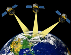
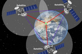
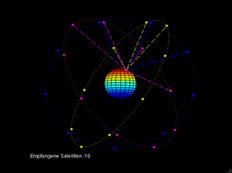
GNSS uses the concept of trilateration. The following note and images are provided to understand the concept.
Trilateration is a mathematical technique used by a global positioning system (GPS) device to determine user position, speed, and elevation. By constantly receiving and analyzing radio signals from multiple GPS satellites and applying the geometry of circles, spheres, and triangles, a GPS device can calculate the precise distance or range to each satellite being tracked.
Source: Lifewire, available at, https://www.lifewire.com/trilateration-in-gps-1683341
Images by Science ABC
|
iGPS is a US global positioning system, originally created for use by the US military, using satellite technology and time code information to provide a precise global location.
GLONASS is an acronym, which stands for Globalnaya Navigazionnaya Sputnikovaya Sistema, or Global Navigation Satellite System. GLONASS is Russia’s version of GPS (Global Positioning System).
Galileo is Europe’s global navigation satellite system, providing a global positioning service under civilian control. Galileo is interoperable with GPS and Glonass. By offering dual frequencies as standard, Galileo is set to deliver real-time positioning accuracy down to the metre range.
BeiDou (BDS) is China’s independently constructed and operated navigation satellite system. BDS provides all-time, all-weather and high-accuracy positioning, navigation and timing services to global users.
ii Meaconing, intrusion, and jamming are deliberate actions intended to deny an enemy the effective use of the electromagnetic spectrum. Interference is the unintentional disruption of the effective use of the electromagnetic spectrum by friendly, enemy, or atmospheric sources. Collectively, meaconing, intrusion, jamming, and interference incidents are referred to as MIJI incidents.
[i]GPS is a US global positioning system, originally created for use by the US military, using satellite technology and time code information to provide a precise global location.
GLONASS is an acronym, which stands for Globalnaya Navigazionnaya Sputnikovaya Sistema, or Global Navigation Satellite System. GLONASS is Russia’s version of GPS (Global Positioning System).
Galileo is Europe’s global navigation satellite system, providing a global positioning service under civilian control. Galileo is interoperable with GPS and Glonass. By offering dual frequencies as standard, Galileo is set to deliver real-time positioning accuracy down to the metre range.
BeiDou (BDS) is China’s independently constructed and operated navigation satellite system. BDS provides all-time, all-weather and high-accuracy positioning, navigation and timing services to global users.
[ii] Meaconing, intrusion, and jamming are deliberate actions intended to deny an enemy the effective use of the electromagnetic spectrum. Interference is the unintentional disruption of the effective use of the electromagnetic spectrum by friendly, enemy, or atmospheric sources. Collectively, meaconing, intrusion, jamming, and interference incidents are referred to as MIJI incidents.