- Author
- A.N. Other
- Subjects
- History - general
- Tags
-
- RAN Ships
- None noted.
- Publication
- June 2021 edition of the Naval Historical Review (all rights reserved)
By Walter Burroughs
This article continues a story from Weather Islands published in the March 2021 edition of this magazine. The first article told us a lot about the weather station but little of the history of the island – who was Willis and where and when were the islands discovered, etc.
Discovery and Naming of the Islands
The barque Cashmere was a well-found vessel owned by Henry H. Willis and Company1 which brought many early settlers to New Zealand. She made five voyages to Auckland, two to Lyttleton and one each to Nelson and Dunedin, mostly under command of the popular Captain George Pearson. She could accommodate over 100 passengers in comfort, ranging from superior cabins at 40 guineas to steerage, for single men only, at 18 guineas. Many passengers also sought this ship when making a return trip to the Homeland.
We are indebted to Mr Cameron Venables of the Queensland Government Department of Natural Resources, Mines & Energy who provided information from The Nautical Magazine & Naval Chronicle of 1853, with the following extract of correspondence from the owners of Cashmere.
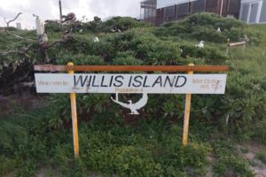
Welcome to Willis Island, described by one resident as ‘A Desolate place with lots of Bird Poo’
Henry H. Willis and Co 31st October 1853
3 Crosby Square.
Admiral Sir Francis Beaufort, KCB
Hydrographer to the Admiralty, Whitehall.
New Islands in Torres Strait
Sir, – We beg to hand the annexed copy of a portion of a letter just received from Captain George Pearson of our ship Cashmere, regarding the presumed discovery of some islands a short distance from the southern entrance to the Torres Strait.
Should this be any new discovery, we disclaim all desires to have these islands named after ourselves, but merely forward you the present information, supposing it may be useful.
We are, Sir, your obedient servants,
Henry H. Willis & Co
Report of the ‘Cashmere’
The ‘Cashmere’ left New Plymouth, New Zealand, July 12th 1853, on her way to India, via Torres Strait. For the first part of the passage experienced a continuance of heavy squalls, and gales of wind from the NW, with heavy rain, until July 28th, in lat 22°29ʹS, from whence southerly winds and fine clear weather. On Tuesday, August 2nd at 3 pm, saw the Alert Reef, and not being able to weather it, tacked and stood to the southward. At daylight nothing visible from the masthead; bore away to the WNW.
Tuesday, August 4th, 6 am, saw two islands covered with bushes, from 18 to 20 feet high, apparantly with a fine sandy beach; one bearing WNW the other NE, by compass, not being marked on any of our charts, nor in Horsburgh’s Directory2. Hauled up the courses, and laid a fore-yard to the mast, and drifted down mid channel. At 7 am the following bearings were taken by the azimuth compass: – West Island, north end, SW by W½W; south end, SW½W, with heavy breakers from the SW end. East Island, north end, NE by E½E, south end E by N½N, with heavy breakers extending 3 or 4 cables’ length from the NW end.
8 am – Bore away NW by N½N; position of ship at noon, by good sights, lat 16°22ʹS, long by chron. 149°38ʹE, which by course made good since time of bearings places the East Island in lat 16°53ʹS, long 149°51ʹE, west side; West Island lat 16°55ʹS, long 149°43ʹE, east side, visible from the deck between 9 and 10 miles distant.
Should the above-described islands not have been previously noticed, I shall call them Willis’s Islands, in compliment to the owners of the ‘Cashmere’.
Royal Naval Surveys
We have to thank Ms Ann-Marie Fitzsimmonds, Archives Research Administrator, UK Hydrographic Office, for her helpful assistance and guidance to surveys conducted by Captain Henry Mangles Denham, RN, FRS, in HMS Herald.
Early navigators needed a safe and quick route outside the Great Barrier Reef linking eastern Australian, Tasmanian and New Zealand ports to Singapore and beyond. They were very conscious of a number of reefs reported in the Coral Sea, with the position of many remaining dubious. These included Bougainville Reef, Diane Bank, Lihou Reef and Mellish Reef. The discovery of the Willis Islands prompted the Royal Navy into action. The survey ship HMS Herald,under the command of Captain Denham, RN, (later Vice Admiral Sir Henry Denham) was based on the Australia Station from 1852 to 1861. The Coral Sea islands were one of the last Australian surveys conducted by the redoubtable Captain Denham in Herald.
Denham first sighted the Willis Islands early in the morning of 22 February 1860 reporting: ‘A long low sandy cay was sighted ahead, extending about 1 mile in an east-west direction’. As they approached, he could see a reef extending three miles east and southeast from it. Shortly afterwards two grassy islets were sighted four and six miles south of the cay. Passing west of the sandy cay and its surrounding reef, Denham found himself on a bank with depths of about 30 fathoms over it, extending about three miles west of the two islets.
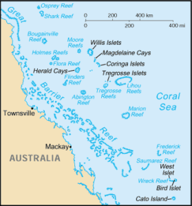
They anchored overnight and the following morning Captain Denham and the ship’s Master, Mr Francis Hixson3, after a four mile pull in an unpleasant sea, landed on the northern of the two grassy islets in time to take the usual set of observations. Denham and Hixson were therefore the first persons known to set foot on these islands. Two other survey parties from the ship took up positions on the reef. By sunset sufficient observations had been taken to determine the extent of what was clearly Willis Islets. The position obtained of the northern grassy islet was 16°13ʹ 00” S, 150°02ʹ24” E, the group extended six miles north and four and a half miles south. The tidal hour at high water full and change was VIII hours and the range of the tide six feet.
The differences in position, shown in the table below, between Cashmere and Herald are noteworthy with an unexplainable 40 minutes of latitude, but only 15 minutes of longitude with the latter being understandable in the days before radio time checks. Minor differences between satellite navigation and Herald may be explained by differences in geographic positioning taken by these systems.
| Willis Island | Latitude | Longitude |
| Satellite Navigation | 16°17ʹ S | 149°58ʹ E |
| HMS Herald | 16°13ʹ S | 150° 02ʹ E |
| Ship Cashmere | 16°54ʹ S | 149° 47ʹ E |
Following the Heraldsurvey, the Willis Islands, together with a number of other remote islands which for hundreds of years had been the breeding grounds for seabirds, were exploited for guano in the 1870s and 1880s. When this rich fertiliser was exhausted they were abandoned. This would also account for a dramatic change in the vegetation, taking most of the exposed surface back to bare rock.
There is another pertinent reference from the Royal Naval Hydrographer concerning the history of these islands, addressed to The Director of Navigation, Commonwealth of Australia, Central Office, Chelford House, Melbourne, which reads:
Hydrographic Department 15 November 1921
Admiralty
London S.W.1
Sir,
With reference to your communication of 21st September last, AG/FF N.21/, enquiring of this Department whether any records exist at the Admiralty of the discovery and early history of the Willis Islands in connection with the proposed erection of the Wireless Station on the South Island. I have the honour to inform you that this question has already been investigated at the request of the Colonial Office and an extract from the reply thereto, embodying the results of that investigation, is forwarded herewith for your information.
I have the honour to be, Sir,
Your obedient Servant,
(Sgd) N.W. Kennie
for Rear-Admiral & Hydrographer
Extract
They were discovered in the year 1853 by Captain Pearson, of the ship ‘Cashmere’, who named them the Willis Islands, after the owners of his vessel. They were surveyed in February 1860, by Captain H.M. Denham, RN in HMS ‘Herald’. Captain Denham landed on the middle islet on February 23rd of that year, and buried a bottle containing a record of his visit and movements. His journal contains no reference to any annexation having been affected at that time, and it is kept in such detail as to render this practically absolute prime facie evidence that such did not take place.
In this connection it may be interesting to recall that possession of the whole East of Australia, and of the off-lying islands, was taken by Captain Cook at Possession Island, near Cape York, on Wednesday August 22nd 1770.
The group has not been surveyed since Captain Denham’s time. The nearest land to it in the possession of a foreign power is the Chesterfield group, belonging to France, some 550 miles to the south-eastwards.
The use of this vague ‘Cook’ interpretation of off-lying islands to an undetermined meridian seemingly gave the Imperial authorities sufficient justification to claim the Willis Islands as lying within the jurisdiction of the Australian Government.
An Early Warning Station
During the early years of the 20th century there were many calls on the recently formed Commonwealth Government to provide some sort of early warning against the impact of tropical cyclones on the Queensland coast. Shipping authorities were also becoming increasingly worried about the losses to coastal shipping with the passenger/cargo steamers Yongala(122 souls) and Koombana (150 souls) both lost with all hands in tropical cyclones in 1911 and 1912.
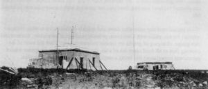
In 1918, two severe tropical cyclones crossed the coast, one of which devastated Innisfail and the other Mackay. This was probably the turning point as the Minister for Home and Territories was subsequently persuaded that a wireless storm warning station on a Coral Sea island would be of great benefit. During 1920, correspondence between his department and various other departments about how this might be achieved was exchanged.
In June 1921 the launch Mandalay sailing from and returning to Townsville conducted a survey of the Willis and nearby groups of islands. At the time it was thought that hurricanes (as tropical cyclones were then known, still using the European, North Atlantic nomenclature) originated between 8° and 10° South and then travelled southwest to meet the Queensland coast between 15° and 24° South travelling in an arc and eventually moving away to the southeast. Thus, it was reasoned that a station in this general area could provide the early warning needed. The ensuing report from Mr A. S. Macdonald of the Postmaster General’s Radio Service stated that the southwest islet of the Willis group would be a suitable site for a radio-telegraph station.
A station was subsequently approved by the Federal Government but no action was taken to progress it. In September 1921 a meeting of various departmental heads was convened to form an action plan. After several hours of discussion, it was decided that there was insufficient time to prepare for the establishment of a station before the coming hurricane season. The meeting also expressed grave doubts about the safety of anyone left on the Island.
Captain Davis4 was however convinced that such a station could be ready in time, after all the Commonwealth had labelled its establishment ‘Urgent’. He spoke with the Minister for Home and Territories, the Hon. A. Poynton and offered to serve as meteorological observer during the first season. Thus, on 1 October 1921 a party of 15 left Melbourne in the Howard Smith steamer Cooma bound for Townsville. There they transferred to the appropriately named steamer Innisfailwith 150 tons of cargo, mainly construction materials.
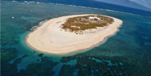
The working party set foot on Willis on October 14th, 1921, and settled into a rugged routine. The main island has an area of some fifteen acres and is approximately 520 metres long by 130 metres wide, and 9 metres above sea level at low tide. It is a coral reef with no natural soil, but some has been deposited there for growing vegetation. This has not been fully successful, and it could not be termed a gardener’s paradise. At low tide the rock pools are exposed, showing the colourful coral and an abundance of picturesque fish that inhabit them.
The working party’s first task was to build a tramway from the beach to the site of the buildings for the ease of moving materials and equipment. The priority order was habitable living quarters, a wireless hut, the erection and guying of two 26-metre-high radio masts and the installation of the radio and meteorological equipment. This was accomplished in just three weeks and the island was claimed for the Australian Commonwealth by a flag raising ceremony on November 7th.
Next day, at 9 a.m., Captain Davis radioed the first meteorological observation from the island. During the 1920s the station was manned by a Bureau observer and two operators during the cyclone season, and by two operators only during the north-east trade wind season, with wireless operators from Amalgamated Wireless (Australasia) Ltd. (AWA). From June 1931, it was staffed by only two AWA personnel, but the Bureau returned to the scene with the outbreak of WWII. After the war the Overseas Tele-communications Commission assumed responsibility for radio communications and in 1966 the Bureau took over sole control, which it holds to this day. Entertainment on the island is limited, but has been updated through the years. A television set is installed but conditions vary and reception is not guaranteed.
Present Day
The present-day story of Willis Island has been adequately covered in the March 2021 edition of this magazine. It is also of note that of recent times, prior to COVID-19 interruptions, sail-past voyages to Willis Islands have appeared on cruise ship itineraries. P&O Australia made regular voyages from the Queensland coast to Willis Island – if weather conditions were suitable they anchored off and sent a boat inshore with newspapers and mail for the lonely weathermen.
Notes:
- Owing to a disagreement, partners left Willis & Co in 1856 to set up a rival company which was to become the well-known Shaw, Savill & Albion Line trading between Great Britain and Australia and New Zealand. It is perhaps ironic that on 19 February 1960 the Shaw Savill liner Runic on passage from Brisbane to Auckland went aground on Middleton Reef; after attempts to refloat her failed she was declared a constructive loss.
- James Horsburgh (1762-1836) was a Scottish hydrographer employed by the East India Company who produced early sailing directions for mariners. Horsburgh’s Directory became a standard work carried by most ocean-going ships trading to the east.
- Francis Hixson served as Master under Captain Denham and later settled in NSW where he became Superintendent of Pilots, Lighthouses and Harbours. He helped organise the Volunteer Naval Brigade, becoming Captain Commanding Naval Forces in the colony.
- Captain John King Davis CBE (1884-1967) was a Master Mariner (Extra Master) and LCDR RANR, who had served in various Antarctic expeditions and was responsible for the establishment of meteorological stations on Willis Island and the sub-Antarctic Macquarie Island. From 1920 until retirement in 1949 he was the Commonwealth Director of Navigation.
References:
David, Andrew, The Voyage of HMS Herald to Australia and the Southwest Pacific 1852-1861 under the command of Captain Henry Manges Denham. Miegunyah Press, Melbourne, 1995.
Davis, John K., Willis Island: a storm warning station in the Coral Sea. Government Printer, Melbourne, 1922.
Denham, Henry M., An Exploring Cruise in the Coral Sea, As journalled by Captain Denham, RN, FRS of HMS Herald21 January to 23 May 1860, Sydney Morning Herald, 05 to 07 September 1860.
Fletcher, Peter, Seventy-Five Years at Willis Island, Bureau of Meteorology, Melbourne, 1996.
Lansley, Belinda, The Cashmere: New Zealand Immigration Ships 1851-1863, Rock Your Boat Publishing, London, 2016.
