- Author
- A.N. Other
- Subjects
- History - general, Ship histories and stories
- Tags
-
- RAN Ships
- HMAS Barcoo, HMAS Flinders, HMAS Warrego II, HMAS Moresby II, HMAS Melville, HMAS Leeuwin, HMAS Diamantina I, HMAS Paluma III
- Publication
- March 2022 edition of the Naval Historical Review (all rights reserved)
By Kevin Slade, PSM & John Perryman, CSM
This article first appeared in the 2020 edition of Navy Outlook and is reproduced by kind permission of the editor of that magazine and the authors.
Hydrographic surveying in Australia began with Lieutenant James Cook’s first charting of the eastern seaboard in HM Barque Endeavour.
Cook’s work was followed by voyages of exploration around the Australian coastline conducted by Matthew Flinders, Nicolas Baudin, Phillip Parker King, John Wickham, John Lort Stokes, Francis Blackwood, Owen Stanley, William Bligh, James Grant and others until, by the mid-19th century, the shape of the Australian continent and most of its coastal waters was known.
The story of the Australian Hydrographic Service from those early beginnings to the internationally respected organisation it is today is one of resourcefulness and persistence, spurred on by the strategic and economic interests of our island nation.
Origins of the RAN Hydrographic Service
Before federation, the Australian colonies contributed to the conduct of hydrographic surveys and from 1908 the Commonwealth Government paid the Royal Navy half of the cost of surveys carried out in Australian waters. Those surveys were later supported by staff in the Admiralty Chart and Chronometer Depot first established in Sydney in 1897 and later taken over by the Royal Australian Navy in 1913 at which time it became known as the RAN Hydrographic Depot.
World War I
At the outbreak of World War I the Royal Navy surveying ship on the Australian Station was HMS Fantome. Her surveying duties ceased in November 1914 when the ship was transferred to the RAN, armed and detached for blockade and patrol service operating chiefly in the Bay of Bengal, the Andaman and Nicobar Islands.
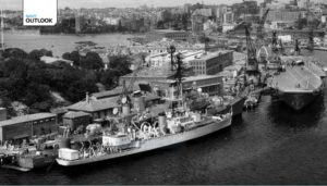
In the absence of Royal Navy survey ships on the Australian Station, very little survey work was undertaken by the RAN. An exception being a survey conducted by HMAS Una of Sewa Bay at Normanby Island, New Guinea in 1915.
Following the Great War, the Admiralty informed the Australian Government that:
…no increase in the Admiralty Surveying Service in ships or personnel can be hoped for and the immediate need for work in Home Waters renders it impossible to divert vessels for further surveying in the Dominions.
The inter-war years
The question concerning the creation of an Australian hydrographic department came to a head in the 1919 Naval Defence Report, which provided the Australian Government with alternative models on which to base a hydrographic service—be it naval or civilian. It was subsequently decided that the RAN would form its own Hydrographic Service, funded from within the naval budget.
The RAN Hydrographic Service was officially formed on 1 October 1920, with Captain John F. Robins, RAN, being appointed its first hydrographer and Mr Cyril Woodhouse its first cartographer in January 1921. By that time Fantome had resumed surveying duties, complemented by the sloop HMAS Geranium.
In 1922 the Hydrographic Office was re-located to Victoria Barracks, Melbourne, and for the next five years the Admiralty maintained a Royal Navy, surveying ship in Australian waters, with HMS Herald replacing Fantome in 1926.
In response to calls for a modern survey of the Great Barrier Reef, HMAS Geranium was tasked to proceed to Queensland waters in February 1924. The strategic and commercial value of this task was of great importance to Australia and to aid in the assignment the ship was modified to carry a small Fairey IIID aircraft for the purpose of aerial reconnaissance. She was later joined by HMAS Moresby, another former Royal Navy sloop, commissioned in the RAN on 20 June 1925.
In 1927 Geranium was paid off but Moresby continued the survey until the end of 1929 at which time she was placed in reserve following drastic Defence cuts owing to the Great Depression. With few vessels conducting surveys in Australian waters it was hardly surprising that growing dissatisfaction among commercial shipping circles led to Ministerial intervention.
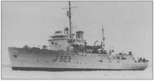
In 1937 the Ministers for Defence and Commerce appointed a technical committee to make recommendations concerning increasing survey operations, having regard to safety of navigation, cost and the period over which survey work would have to be spread.
With a possible war looming, conditions in England required all services to be committed to rearmament and the Admiralty could offer little assistance. Moresby at that time was fully engaged on strategic surveys and if this important work was to continue, Australia would have to come up with other solutions. This would see a variety of RAN vessels and craft taken up from trade, take on surveying duties in the ensuing years including a number of Bathurst class minesweepers and Harbour Defence Motor Launches.
World War II
When the Pacific War erupted in December 1941 the Allies possessed very poor chart and map coverage of strategic areas including the Solomons, New Guinea and Northern Australia where large areas remained unsurveyed. Rapid hydrographic surveys would be vital to making these reef-strewn waters safe for warships and this work was entrusted to various hydrographic and topographic units. In the Southwest Pacific, the task of surveying New Guinea was given to the Royal Australian Naval Surveying Service.
By then Moresby was back in service performing escort duties but at times she resumed her old trade, carrying out surveys of the Great North East Channel, Great Barrier Reef openings, Blanche Bay and Rabaul Harbour.
In July and August 1942, hydrographic information provided by the small surveying tender HMAS Kwato enabled ships to move into Milne Bay while preliminary surveys by HMA Ships Whyalla, Stella and Polaris were to prove invaluable during the Buna campaign.
As Allied armies advanced during 1943, RAN surveying ships were formed into Task Group 70.5, part of the US Seventh Fleet, and the Australian Hydrographic Service was designated the charting authority for Allied naval forces in the South West Pacific.
During 1944 Australian surveying vessels undertook several daring exploits as part of forces conducting initial operations preceding amphibious landings. The corvette HMAS Shepparton surveyed a channel through the Japanese-controlled Dampier Strait prior to the landing at Cape Gloucester. For the occupation of the Admiralty Islands, HMAS Benalla accompanied the invasion force undertaking a survey of Seeadler Harbour while it was still partly in enemy hands. In the landings that followed, surveying vessels routinely formed part of mine sweeping flotillas, marking cleared channels and undertaking important preliminary surveys.
The Australian Hydrographic Service also participated in landings at Morotai, Leyte Gulf, Lingayen Gulf, Subic Bay, Zamboanga, Mindanao, Tarakan, Brunei Bay and Balikpapan. It conducted surveys across Australia’s northern waters and through the Timor and Arafura Seas, including waters largely unsurveyed since the days of the early navigators. This work provided a swept navigational route for battleships transiting from the Indian to Pacific Oceans and mine sweeping and survey operations through the restricted waters of Torres Strait enabled ships of all sizes to safety use it by day or night.
Three notable hydrographic surveyors were killed in action during 1941 and 1942. Commander W.H. Martin, RAN, was lost when HMAS Perth was sunk during the Battle of Sunda Strait. Lieutenant Commander R.W. Rankin, RAN, was killed at his post while in command of HMAS Yarra when she was engaged by overwhelming Japanese naval forces while escorting a convoy south of Java; and Lieutenant G.W.A. Langford, RAN, was killed when a German U-Boat torpedoed and sank HMAS Parramatta in the Mediterranean on 27 November 1941. Their loss was deeply felt across the fledgling surveying community.
Despite its small number, Australia’s surveying service received an impressive list of awards and decorations during World War II including two Order of the British Empires (OBE), thirteen Distinguished Service Cross’s (DSC), four Distinguished Service Medals (DSM), fourteen mentions in despatches, as well as United States Legion of Merit awards. In addition, Commander KE Oom, OBE, RAN, was awarded the Gill Memorial Award by the Royal Geographical Society of London in recognition of the RAN Surveying Service’s contribution to the geographical knowledge of New Guinea waters.
By 1945, the Royal Australian Naval Surveying Service comprised the RAN sloops Warrego and Moresby; the frigateLachlan; the corvettes Benalla, Shepparton, Horsham, Echuca and Castlemaine; the trawlers Stella, Polaris, Winter; the lighthouse tenders Cape Leeuwin and Bangalow; and three harbour defence motor launches.
The Post-War Era: 1946 to 1960
The Australian Federal Cabinet considered the future of the Australian Hydrographic Service in 1946, determining that the RAN would remain the charting authority for hydrographic surveys of Australian waters and of Australian spheres of influence in the Pacific. Cabinet also endorsed a 25 year program to achieve this purpose.
HMA Ships Warrego, Lachlan and Barcoo were employed as survey ships between 1946 and 1948, surveying the southern Great Barrier Reef, Spencer Gulf, Bass Strait and the North West coast of New Guinea. Three years later manning and other difficulties forced the RAN to reduce the surveying ships’ complements but harbour surveys continued from ships immobilised at Sydney.
In 1947 the RAN Hydrographic Service commissioned the unusually named HMAS Wyatt Earp to support Antarctic exploration. Under Commander K.E. Oom, RAN, she sailed from Hobart on 26 December for Antarctica. Her objectives included a reconnaissance of the coastline of King George V Land, to evaluate the prospects of establishing an Australian base in the Commonwealth Bay area. However, while to the South of Macquarie Island she was plagued with mechanical defects and ordered back to Williamstown, Victoria. She sailed again on 8 February 1948 carrying out a running survey of the Balleny Islands. On her return voyage she called at Macquarie Island rendezvousing with HMA LST 3501 that was landing an expedition on the island.
For three years no progress was made on the national survey but in 1952 surveying was resumed by HMA Ships Warrego and Barcoo. In 1958 HMAS Paluma commissioned, joining them in this important endeavour.
On 22 June 1959 the river class frigate HMAS Diamantina recommissioned as an Oceanographic Research Ship, under the command of Lieutenant Commander Bruce D Gordon, RAN. Over the following two decades she undertook oceanographic survey duty, mainly off the Western Australian coast and in the Indian Ocean and Java Sea. During those surveys she carried scientists from the Commonwealth Scientific and Industrial Research Organisation (CSIRO) and assisted the Australian Army Survey team on the north-west coast of Australia.
In February 1960, scientists aboard Diamantina discovered a fissure in the ocean floor west of Cape Leeuwin that dropped to depths of over 4000 fathoms. Now known as the Diamantina Trench, it is believed to be the deepest recorded water in the Indian Ocean.
Rapid change: 1961 to 1973
Discoveries of large mineral deposits led to a dramatic increase in Australia’s export earnings during the 1960’s and early 1970’s. It also changed the type and size of shipping used to transport Australia’s export commodities. The opening of new ports and a rapid increase in the tonnage of shipping was to shape the work of the AHS for the next 15 years.
HMA Ships Barcoo, Warrego and Paluma subsequently conducted surveys of new deep draft shipping routes through the Great Barrier Reef, Torres Strait and the Gulf of Carpentaria and of the approaches to the new mineral ports of Weipa, Port Headland, Dampier and Gove. The commissioning of HMAS Moresby (II), Australia’s first purpose designed survey vessel, replaced Barcoo and Warrego in 1964. By 1992 she had attained an impressive 1 million nautical miles in the course of her surveying duties.
In 1966 the RAN Hydrographic School was established at HMAS Penguin, Mosman, NSW. Today it is known as the Maritime Geospatial Training Center and it continues to train naval officers and sailors to international standards.
During the 1960s the face of hydrographic surveying changed with the fitting of Decca, LAMBDA and HI-FIX electronic position fixing systems to survey ships. These systems replaced visual and radar position fixing, remaining in service until the late 1970s.
New technology and opportunities: 1973-1993
By the mid-1970s the surveys of main deep draught shipping routes and approaches to key mineral ports around Australia had been completed to modern standards clearing the way for increased usage.
Insert phot which I have called Hydro 3 – note there is no title
On 27 April 1973 a new hydrographic survey ship (small) HMAS Flinders commissioned in the RAN as a replacement for HMAS Paluma. Named after the famous Royal Navy navigator and cartographer, she was to spend much of her service life surveying the Great Barrier Reef, Papua New Guinea and the Coral Sea. In 1974 she was the first RAN ship to enter Darwin following the devastation caused by Cyclone Tracy clearing the way for seaborne relief efforts.
Transit Satellite Navigation systems entered service in 1973 for offshore surveys, followed by shore-based systems to establish geodetic control. LAMBDA and HI-FIX were replaced by Cubic Western ARGO with thermal generation power supply, Motorola Mini-Ranger became the new short range electronic position finder with wind and solar power generation and new shallow and deep water echo sounders replaced systems which had been in use for 30 years.
The Hydrographic Logging and Processing System (HYDLAPS) was installed in RAN hydrographic ships in the years that followed and the Autochart System entered service in 1978 for the production of nautical charts. The Global Positioning System (GPS) replaced other electronic position fixing systems in the late 1980s.
Complementing the work of the RAN’s hydrographic ships was the oceanographic research ship HMAS Cook.Commissioned in the RAN on 28 October 1980 she replaced HMAS Diamantina in the oceanographic research role. Cook was the first RAN ship specifically designed for oceanographic duties remaining in commission until 1990 having undertaken a number of important scientific deployments.
A Laser Airborne Depth Sounding (LADS) capability was introduced in 1993. The system used the difference between the sea surface and the sea floor as calculated from the aircraft’s altitude to generate hydrographic data. Initially, a modified Fokker F27 aircraft, supported by a ground-based processing and validation unit was used. Later the system was refitted to a Hawker De Havilland Dash 8 in 2010.
In relatively clear coastal waters LADS proved to be highly effective. Its productivity and area coverage was so good that surface units were routinely not tasked to these areas. In regions of poor water clarity LADS was a complementary capability to surface survey units. More than 26 years after the first experimental laser flew, this Australian designed system remained at the forefront of both laser based systems and hydrographic survey systems in general. In total, the LADS Flight flew more than 3,000 sorties, conducting 186 surveys and covered an area of more than 50,000 square kilometres. It was withdrawn from service on 6 November 2019.
In 1979 the Australian Government instituted a program to establish a hydrographic capability in the Solomon Islands under the Defence Co-operation Program (DCP). This saw a Chief Petty Officer Survey Recorder (CPOSR) posted to the Solomon Islands Marine Division (SIMD) in Honiara. The AHS also chartered a Department of Transport vessel, MV Cape Pillar, and with a small contingent of hydrographic personnel embarked, conducted surveys in the waters of the Solomon Islands, Vanuatu and Samoa from 1982 to 1989.
A similar program operated in Vanuatu from 1987 to 1995 while in Fiji several hydrographic officers assisted in supporting that country’s hydrographic program during the 1980s. Australia also assisted Southwest Pacific countries by providing hydrographic and cartographic training at the Hydrographic School in Sydney.
In 1985 the AHS resumed Antarctic operations conducting survey reconnaissance at various Australian Antarctic stations. The Hydrographic Office Detached Survey Unit (HODSU) commenced annual deployments in 1987, which continued for 15 years using the Survey Motor Boats Deliverance and Wyatt Earp. When not on Antarctic duties, HODSU conducted surveys throughout Australia deploying on active service during the INTERFET Operation in East Timor in 1999-2000.
From 1989 to 1990 four new survey motor launches (SML) HMA Ships Paluma, Mermaid, Shepparton and Benallawere commissioned in the RAN. Designed for operations in the shallow waters of northern Australia they generally operate in pairs with their twin hull design providing good stability in most conditions. Each SML carries the latest in survey and computerised hydrographic data processing equipment and is fitted with the latest navigation aids.
1994 to Present
In 1994 the Australian Hydrographic Office moved to its current location in Wollongong. It remains a repository for hydrographic information in Australia preserving many original surveys, hydrographic and oceanographic data and archival copies of published Australian and British Admiralty charts.
In 1997 HMAS Moresby decommissioned and Flinders followed soon after in 1998. Two new vessels, HMA Ships Leeuwin and Melville, commissioned in Cairns in 1999 and along with the survey motor launches, LADS flight and Deployable Geospatial Support Team (DGST) they assumed responsibility for the hydrographic survey of Australia’s area of charting responsibility.
Throughout the first two decades of the 21st century the Australian Hydrographic Service continued conducting frequent surveys around the Australian coast and in the South Pacific. At times its ships and personnel have also contributed to constabulary, humanitarian and military operations.
Between October 2008 and December 2009 one of the Hydrographic Branch’s most senior members, Commodore Bruce Kafer, AM, CSC, RAN, was appointed in command of two combined task forces, CTF 158 and CTF152, in the Arabian Gulf. There he was responsible for the coordination and execution of maritime security and interception operations in the Middle East Area of Operations. He was later appointed the commandant of the Australian Defence Force Academy from 2009 – 2013.
Several of the RAN’s hydrographic ships performed important border protection duties in support of Operation RELEX. Others rendered assistance to the civil community in the wake of natural disasters such as Cyclone Debbie that crossed the coast of Queensland in 2017. In other maritime operations hydrographic ships have actively participated in a number of major exercises proving their worth in simulated minefield lead-through operations and other specialised tasks.
On 6 August 2017 HMAS Melville was instrumental in locating the wreckage of a United States Marine Corps (USMC) MV-22 Osprey aircraft that ditched in the vicinity of Shoalwater Bay during exercises, killing three US Marines. Using the ship’s Towed Lightweight Side Scan Sonar the wreck of the aircraft was discovered in short order in 59 metres of water. This enabled the aircraft and the remains of those on board to be recovered. Melville’s crew was among 107 ADF personnel whose efforts were recognised through the award of a Meritorious Unit Citation later presented by the USMC.
On 16 October 2017 the Defence Legislation Amendment Bill 2017 was passed, receiving Royal Assent to consolidate the Australian Hydrographic Office into the Australian Geospatial-Intelligence Organisation (AGO). Later that year, in December, Commodore Fiona Freeman, RAN, was appointed the first female Australian Hydrographer.
Today the Australian Hydrographic Office is responsible for providing Australia’s national charting service under the terms of SOLAS and the Navigation Act 2012. This role requires provision of nautical charting and associated services in support of maritime safety, the coordination and determination of policy and standards that cover both hydrographic surveying and charting, as well contributing to the coordination, exchange and standards related to maritime geospatial data in general.
The AHO is also responsible for providing direct support to the Australian Defence Force (ADF) by providing hydrographic, charting, oceanographic and meteorology services.
Over the last 100 years the RAN’s hydrographic personnel have contributed significantly to preserving maritime security in peace and war. Their work often takes place in the remote far reaches of Australia and its surrounds, well out of sight of the many who make use of the charts and other important navigational data produced by them. When warships of the RAN fleet deploy, they do so confident in the navigational data provided by the ships and personnel of the Navy’s survey fleet.
