- Author
- van Gelder, Commander John RAN (Rtd)
- Subjects
- Ship histories and stories
- Tags
-
- RAN Ships
- HMAS Queenborough
- Publication
- March 2003 edition of the Naval Historical Review (all rights reserved)
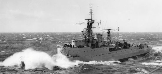
On leaving my cabin I noted the barograph trace had now managed to fall into the blank area of the form in which is written the ship’s name and other significant details. I thought this to be rather unusual and certainly unfriendly to mariners! The atmospheric pressure appeared to be about 965 millibars. On the bridge nothing had changed, except the wind strength, which was hovering between 70 and 80 knots. The sky was completely overcast and the enormous swell was still enormous, or even more so if that were possible. I was very thankful that Type 15 frigates were designed with enclosed bridges, although ours at the time was cold, damp, stuffy and constantly wet underfoot.
At about 0645 a most extraordinary phenomenon occurred, which caught me completely by surprise and, in reality, took me a minute or so to appreciate. Within a space of time, perhaps no more than two minutes, the wind which had been blowing at 70 or 80 knots, simply died to nothing. For the past thirty six hours or so we had been subject to the noise of constant smashing of heavy salt water spray against the windows and side of the bridge and the high pitched howling of the wind. Now, so suddenly and unexpectedly, barely a sound could be heard, apart from the familiar sounds of the ship underway.
The situation, which for me took a minute or two to comprehend, was that we had simply entered the eye of a cyclonic depression with a significantly low central pressure. It was an eerie feeling to stand on the bridge with the ship ploughing through a 15 metre swell at 18 knots with the water surface undisturbed by wind ripples. The seas had moderated on the swells to give almost an oily appearance to the surface. Although I had read of this type of situation I had never experienced a passage through the centre of a depression of this magnitude. The memory of it is still vivid in my mind. On the bridge the feeling seemed to be one of awe at the sudden and dramatic change in the weather and, perhaps, of apprehension as to what was going to happen next.
Realising that we were in the centre of an exceptionally low pressure area I went to the wheelhouse flat to check the reading of the Kew Pattern (mercury) Barometer. This instrument gave a reading of precisely 964 millibars and, in fact, confirmed the readings of the barographs in the navigator’s chartroom and my cabin.
The passage through the eye lasted about forty five minutes. At this time one may have expected to observe some break in the clouds, however this was not to be. The sky remained completely overcast throughout. At about 0730 we emerged from the peace and tranquillity and found ourselves back in the familiar conditions with wind speeds of 70 to 80 knots. Strangely enough, there was not a marked change in wind direction. It had been south westerly and remained approximately so, although backing slightly.
From my visual observations and the barograph recording I can only speculate that our south easterly course had kept us in the Cold Frontal Zone of the approaching intense depression for, at least, the previous twenty four hours. It also seems probable that the depression was relatively slow moving and may have been moving in a roughly northerly or north easterly direction. Certainly the pressure gradient was very steep since our passage through the eye in forty five minutes at 18 knots suggests the eye was about 12 to 15 miles in diameter. This, of course, assuming zero movement of the eye at the time.
Maintaining our south easterly course (at that time 143 degrees) we picked up Macquarie Island on 293 radar about midday at a range of approximately 60 miles. After the severe rolling we had encountered for more than two days, and being uncertain of the degree of surface movement, I was surprised to find that we had only to alter course 3 degrees to starboard to make our intended landfall. I always knew my navigator would make Flag rank, which of course he did some years later.
Visually sighting the Island for the first time I immediately concluded that this was no place in which to spend annual holidays. It appeared to resemble a huge windswept rock covered with sparse green vegetation, shrouded with cloud and located in a most inhospitable part of the world. The Island itself lies in approximately a north south direction, with an isthmus at the northern end, on which is located the Australian National Antarctic Research Establishment (ANARE) base. On either side of the narrow isthmus are two indentations in the coastline, euphemistically knows as bays; the one to the west known as Hasselborough Bay, the one to the east as Buckles Bay.
