- Author
- Editorial Staff
- Subjects
- History - pre-Federation
- Tags
-
- RAN Ships
- None noted.
- Publication
- December 2019 edition of the Naval Historical Review (all rights reserved)
Possession Island is a small and now uninhabited island of 500 hectares lying 17 km to the southwest of Cape York, but it has great significance to our nation. Just before sunset on Wednesday 22 August 1770 this is where Captain Cook is said to have taken possession of the whole of the eastern coast of New Holland and the adjacent islands and named this territory New South Wales.
It should be recalled that at this time Cook was cautiously making his way through uncharted waters navigating through a maze of islands, shoals and reef strewn passages with treacherous tidal races. After rounding Cape York and leaving Possession Island to port and Prince of Wales Island to starboard he proceeded through Endeavour Strait passing Booby Island, and finally making the safety of the Indian Seas.
During his voyage Cook’s manuscript was transcribed on what was known as a holograph. This holograph was handed to his clerk, Richard Orton, who made two copies for the Admiralty. The first was sent ahead from Batavia and is now held by the Mitchell Library in Sydney, and the second was handed to the Admiralty when Endeavour reached England. Cook’s original journal of some 750 pages was presented to his wife and after her death in 1835 it disappeared from public knowledge for many decades, until rediscovered in 1923 when auctioned by Sothebys in London. It was purchased by the National Library of Australia. Added to these we have the official version of the voyage, which on Admiralty instructions, was prepared by Dr. John Hawkesworth and published in 1773. This narrative, with improved literary style, was intended for the general public, and it is this version that is most commonly used.
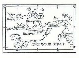
With potentially four versions of the great man’s works, each with minor variations, there is room for ambiguity. The greatest scholar to examine Cook’s works in detail was New Zealander, Dr. John Cawte Beaglehole, who spent most of his adult life in this pursuit. His acclaimed biography of Cook is largely based on his critical examination of the original work held by the National Library of Australia.
Beaglehole tells us that on 22 August 1770 Cook discovered the most northern promontory of this country which he named York Cape (sic). Cook says: ‘At four in the afternoon anchored off a small island in great hopes that we had at last found a passage to the Indian Seas. Landed with Banks and Solander, to the fright of a few people who were seen, and climbed the highest hill. These people were armed with lances and one had a bow and arrow – they were thought to be Melanesian. Here they could see no land between the SW and WSW and had no doubt that there lay a passage’. Just before sunset Cook carried out his final act of annexation with his words becoming a classic in Australian history, which in verbatim reads: xxx
Having satisfied my self of the great Probability of a Passage, thro’ which I intend going with the Ship, and therefore may land no more upon this Eastern coast of New Holland, and on the Western side I can make no new discovery the honour of which belongs to the Dutch Navigators: but the Eastern Coast from the Latitude of 38˚ South down to this place I am confident was never seen or visited by any European before us, and Notwithstanding I had in the Name of His Majesty taken possession of several places upon this coast, I now once more hoisted English Coulers and in the Name of His Majesty King George the Third took possession of the whole Eastern Coast from the above Latitude down to this place by the name of New South Wales, together with all the Bays, Harbours, Rivers and Islands situated upon the said coast, after which we fired three Volleys of small Arms which were Answered by the like number from the Ship.
In his journal Banks records this important occasion (verbatim) thus: Running along shore with charming moderate weather, as indeed we have had ever since our second entering the reef. We observed both last night and this morn that the main looked very narrow, so we began to look out for the Passage we expected to find between new Holland and New Guinea. At noon one was seen very narrow but appearing to wide: we resolv’d to try it so stood in. In passing through, for it was more than a mile in length before it widened very much, we saw 10 Indians standing on a hill; 9 were armed with lances as we had been used to see them, the tenth had a bow and arrows; 2 had also large ornaments of mother of Pearl shell hung round their necks.1 After the ship had passed by 3 followed her, one of whom was the bow man. We soon came abreast, from whence we concluded we might have a much better view than from our mast head, so the anchor was dropd and we prepared ourselves to go ashore to examine whether the place we stood into was a bay or a passage; for as we sailed right before the trade wind we might find difficulty in getting out should it prove to be the former. The 3 Indians plac’d themselves upon the beach opposite to us as if resolved either to oppose or assist our landing; when however we came about Musquet shot from them they all walkd leisurely away. The hill we were upon was by much the most barren we had been upon; it however gave us the satisfaction of seeing a straight, at least as far as we could see, without any obstruction. In the Even a strong tide made us almost certain.
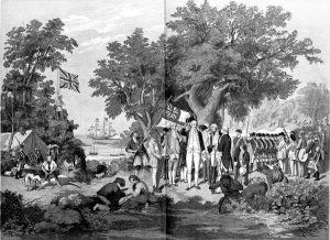
Later scholars have questioned if indeed, Cook ever landed on Possession Island and that this was but an interpretation from his journals made by Dr. John Hawkesworth. Recently, in 2018, a book, Lying for the Admiralty by Margaret Cameron-Ash mounts a strong circumstantial case suggesting fabrication of the annexation ceremony as a ploy to forestall a possible French claim to sovereignty. In 1857 a talented artist John Gilfillan2 provided the public with an idyllic tableau of the Cook annexation ceremony which conveniently passed into folklore.
Cameron-Ash contends that when he was at Batavia in October 1770 Cook rewrote a page in his journal concerning events on 22 August 1770 regarding the landing and passage through Torres Strait. On the earlier date he had named the largest of the Torres Strait Islands Prince of Wales Island, in honour of the recent birthday of the Prince of Wales (born on 12 August 1762 and later to become King George IV). This big island gave Cook a valuable reference point as on Dutch maps this was shown as Hooghe Eylandt (High Island).
From this event Cook later called the coast New Wales and this name was again amended to New South Wales sometime after a copy of his journal had been dispatched to the Admiralty from Batavia. The final name was possibly suggested by Joseph Banks who recalled happy childhood holidays at his uncle’s house in South Wales.
From the above annexation the following are in in contention:
- Previously Cook had landed on the Australian mainland in five places yet there is no mention of a claim of annexation in any of these places in his journals or those written by his officers. This indicates that the Possession Island entry was made after the event by others without sufficient investigation.
- Why did Cook take possession on what is now known as Possession Island, which was clearly inhabited, without any acknowledgement of the native people?
- In Banks’s journal there is a suggestion that Cook had first called this famous landmark Passage Isle and then conveniently renamed it Possession Island.
- Nowhere in Cook’s original journal is there mention of the name New South Wales, so again this was clearly added at a later date.
- Sydney Parkinson3 who was watching his Captain and party ashore writes: The captain, and some others, went to the top of a hill, and, seeing a clear passage, hoisted a jack, and fired a volley, which was answered by the marines below, and the marines by three vollies from the ship, and three cheers from the main shrouds. This indicates the significance of the event was after days of being locked by reef strewn passages they had at last found a way clear and were on their way home, and had nothing to do with annexation.
Subsequent Claims of Sovereignty
To add clarity, in 1786 the first Governor of New South Wales, Arthur Phillip, defined the boundary of New South Wales as extending from the northern extremity of Cape York to the southern coast of Van Diemen’s Land and west to 135 degrees east longitude.
In the early years of the development of the Australian colonies ships were detached from the East Indies Station for service in New South Wales. It was not until 1848 that Captain John Erskine (later Admiral of the Fleet Sir John) was appointed Senior Officer Australian Division of the East Indies Station and, in March 1859, the position was upgraded to Commodore of the Australia Station.
On instructions from the Admiralty Captain Gordon Bremer of HMS Tamar sailed from Port Jackson on 24 July 1824 in company with the colonial brig Lady Nelson and chartered ship Countess of Harcourt to establish a new settlement in northern Australia. On 27 September 1824 they landed on Melville Island and the new settlement was officially proclaimed on 21 October (Trafalgar Day) when Captain Bremer took possession on behalf of HM King George IV of the ‘North Coast of New Holland or Australia’ between the 129th and 135th meridians, including all islands off the coast. The settlement was named Fort Dundas after Robert Dundas, Viscount Melville, who was First Lord of the Admiralty. The settlement was not a success and was abandoned in 1829.
These developments in the north led to a decision in Britain to move the western boundary of New South Wales from the 135th meridian to the 129th meridian. This appears to have been done in 1825 by the issue of a commission of the Governor of New South Wales, Sir Ralph Darling.
HMS Alligator
A supplement to the Sydney Morning Herald dated 22 July 1839 announces an expedition which sailed from Sydney to Port Essington4 under the command of Captain Sir J. J. Gordon Bremer. This relates to Alligator and HMS Britomart,accompanied by the transport Orontes, sailing from Sydney on 17 September 1838. The ships anchored off the Albany Islands in the Torres Strait on 19 October where they found an excellent anchorage. Here on 20 October they took possession of Cape York and the adjacent territory, the British colours being hoisted on a knoll near the summit of the Cape, under a salute from the guard on shore and three cheers which were answered by a royal salute from the ship.
The East India Company had encouraged the British Government to establish a major settlement in northern Australia to rival Singapore. The new settlement would link New South Wales with India. Alligator was conducting survey work at Port Essington under Captain Sir Gordon Bremer when instructions were received for him to sail for Singapore to take command of a new Expeditionary Force being prepared to sail for China to put down an insurrection against British interests. Alligator sailed from Sydney for Singapore in late 1839, it being noted that on 25 November 1839 the settlement at Port Essington was largely destroyed by a cyclone.
The SMH Supplement uses as a reference extracts from journals of Lieutenant Kuper of Alligator. Sir James John Gordon Bremer later became a Rear Admiral and his eldest daughter married Lieutenant Kuper, who had a distinguished career becoming Admiral Sir Augustus Leopold Kuper.
Alligator had an interesting time in southern seas. On 20 March 1834 when under the command of Captain George Lambert, she fired a 21-gun salute at the hoisting of the first national flag of New Zealand at Waitangi in the Bay of Islands on 20 March 1834.
Alligator paid off on 27 August 1835 and recommissioned on 12 July 1837 under the command of Captain J. J. Gordon Bremer, Lieutenant Augustus Leopold Kuper was First Lieutenant. Captain Bremer was promoted to take command of an expedition to put down an insurrection in China. In July 1839 Kuper was given command of HMS Pelorus and was in her when she was driven ashore by a cyclone at Port Essington on 25 November 1839 with the loss of 12 lives, but the ship was salvaged. Captain Kuper later gained command of his old ship Alligator and participated in the Opium Wars.
Returning to Possession Island
The local Kauareg people visited and lived on Possession Island until their forced removal in 1922 to nearby Moa Island. In 1925 a monument was erected on the island by the Commonwealth Government commemorating Cook’s visit.
Other records of commercial activity include that of the schooner Ariel which in 1846 was engaged in collecting trepang (bêche-de-mer) from here and in 1880 four vessels were involved in pearling operations working in this region.
Gold was discovered on Possession Island in 1896 with mining commencing the next year and continuing until 1906. During this period a total of 155.42 kg of gold was produced from 7,245 tons of ore (this includes some from Horn Island). Further attempts were made to reopen the mines in 1919 and 1934 but without success. Today the abandoned workings including several mine shafts and small cuts remain visible.
Summary
There appears little doubt that Possession Island was visited by Captain Cook and from here he was able to find a passage that took him clear of the Torres Strait. The explanation of annexation ceremony is less compelling and may be dubious. The subsequent annexations by Captain Bremer when in HMS Tamar at Melville Island on 21 October 1824 and again when in Alligator at Cape York on 20 October 1838, also the ceremony by Captain Lambert when in Alligator at Waitangai on 20 March 1834 give credibility to the Admiralty’s unease on issues of sovereignty over British possessions in New Holland and New Zealand.
Notes:
- From the description given it seems unlikely that these ‘Indians’ were Australian Aboriginal people, who did not use the bow and arrow or have mother of pearl shell ornaments of this kind. They must have been Melanesians (this footnote is taken directly from Bank’s edited journal).
- John Alexander Gilfillan was Professor of Painting at the Andersonian University Glasgow before migrating to New Zealand in 1842. He moved to Australia in 1847 after his wife and three children were killed by Maori during a period of racial tension. He and his eldest daughter survived serious injuries and two younger children escaped unharmed. The attack was in reprisal for an incident where a young Maori was accidentally shot by a midshipman from HMS
Gilfillan painted a number of scenes and portraits in New Zealand and Australia. He remarried and settled in Melbourne where he died in 1864. In Australia he is best known for his work ‘Captain Cook taking possession of the Australian continent on behalf of the British Crown in 1770’. This was first exhibited in 1857 and is now in the National Library of Australia.
- Sydney Parkinson was a talented young Scottish born botanical illustrator and natural history artist. He was engaged by Joseph Banks to illustrate the thousands of plants and natural history specimens that he and Dr. Daniel Solander collected throughout the Endeavour Parkinson kept a journal which was published posthumously in 1773. He was well liked by officers and crew but sadly his promising career was cut down when he contracted dysentery in Batavia and died at sea before the ship reached home.
- Port Essington is named after Vice Admiral Sir William Essington who is perhaps best known when, in command of HMS Sceptre off Saint Helena in 1795 in company with some East Indiamen, captured eight Dutch East Indiamen laden with valuable cargo on their way home; valued in today’s money at $AUD360 million. He was in command of HMS Triumph at the Battle of Camperdown in 1797 and flew his flag in HMS Minotaur at the Battle of Copenhagen in 1807.
References:
Beaglehole, J. C. (Ed.), The Endeavour Journal of Joseph Banks 1768 – 1771, Volume II, The Trustees of the Public Library of New South Wales, Sydney, 1962.
Beaglehole, John Cawte, The Life of Captain James Cook, Stanford University Press, Stanford, CA, 1974.
Cameron-Ash, Margaret, Lying for the Admiralty, Rosenberg, Sydney, 2018.
Carney, Dr. Gerard, The Story behind the Land Boundaries of the Australian States – A Legal & Historical Overview. Delivered by Dr. Gerard Carney, Public Lecture Series, High Court of Australia, 10 April 2013.
Supplement to the Sydney Morning Herald dated 22 July 1839 which announces an expedition to northern Australia.
