• Skip to primary navigation
  • Skip to main content
  • Skip to primary sidebar

Naval Historical Society of Australia

Preserving Australia's Naval History

  • Events
  • Account
  • Members Area
  • Volunteer
  • Donate
  • Contact us
  • Show Search
  • 0 items
Hide Search
Menu
  • Home
  • Research
    • Where to start
      • Research – We can help!
      • Self help
      • Naval Service Records
      • Library
      • Related Maritime websites
    • Resources
      • Articles
      • Videos
      • On This Day
      • Podcasts
      • Australian Military Ship Losses
      • RAN events on a  Google Earth Map
      • RAN Vessels – Where are they now?
      • Related Maritime websites
    • Other
      • Newsletters: Call The Hands
      • Occasional Papers and Historical Booklets
      • Books
      • HMAS Shropshire
      • Book reviews
    • Close
  • Naval Heritage Sites
    • World Heritage Listings
      • Cockatoo Island
    • National Heritage Listings
      • HMAS Sydney II and the HSK Kormoran Shipwreck Sites
      • HMVS Cerberus
    • Commonwealth Heritage Listings
      • Garden Island NSW
      • HMAS Watson
      • HMAS Penguin
      • Spectacle Island Explosives Complex NSW
      • Chowder Bay Naval Facilities
      • Beecroft Peninsula NSW
      • Admiralty House, Garden and Fortifications
      • HMAS Cerberus
      • Naval Offices QLD
      • Garden Island WA
      • Royal Australian Naval College ACT
      • Royal Australian Naval Transmitting Station ACT
    • NSW Heritage Listings
      • HMAS Rushcutter
    • Close
  • Naval Art
  • Tours & Cruises
    • Navy in Sydney Harbour Cruise, East
    • Navy in Sydney Harbour Cruise, West
    • Anniversary Cruise: Sydney under Japanese Attack
    • Tour Bookings
    • Close
  • About us
    • About Us
      • What we do
      • Our People
      • Office Bearers
      • Become a volunteer
      • Our Goals and Strategy
    • Organisation
      • Victoria Chapter
      • WA Chapter
      • ACT Chapter
    • Close
  • Membership
  • Shop
  • Become a volunteer
  • Donate
You are here: Home / Article topics / Publications / Naval Historical Review / The Remarkable Passage of the Wansfell through the Barrier Reef, 1863-1864

The Remarkable Passage of the Wansfell through the Barrier Reef, 1863-1864

Nicholson, Ian · Sep 6, 1997 · Print This Page

Author
Nicholson, Ian
Subjects
Ship histories and stories, History - pre-Federation
Tags
Torres Strait, Survey, Wansfell, Great Barrier Reef, Brodie H.
RAN Ships
None noted.
Publication
September 1997 edition of the Naval Historical Review (all rights reserved)

For well over a century, until 1977, mariners were intrigued by a warning printed on Admiralty chart BA 2763, amid countless reefs of the outer Barrier Reef, reading:

Reefs seen by Ship `Wansfell’ in her dangerous passage through the Reefs 1864 (chart 1).

The Wansfell warning' (top centre) appeared on this Coral Sea and Great Barrier Reef chart for over 100 years. This chart extract extends from 148° to 150° E, and the latitude line is 20° S. Further Wansfell reef reports were marked some 60 and 110 miles east of the edge of this inset Scale, Bowen-Holborne I = 20'. From Admiralty Chart No 2763, courtesy of Hydrographer RN.
The Wansfell warning’ (top centre) appeared on this Coral Sea and Great Barrier Reef chart for over 100 years. This chart extract extends from 148° to 150° E, and the latitude line is 20° S. Further Wansfell reef reports were marked some 60 and 110 miles east of the edge of this inset Scale, Bowen-Holborne I = 20′. From Admiralty Chart No 2763, courtesy of Hydrographer RN.

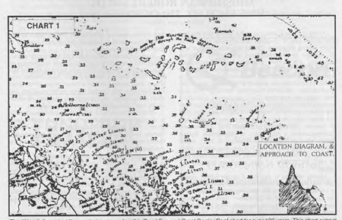
There were two further Wansfell reports in the Coral Sea, 110′ and 135′ to the east.

As a junior officer these certainly fascinated me but I was unable to discover the story behind the notes on the chart. The relevant Australia Pilot or Sailing Directions gave only brief details on two Wansfell Reefs, as part of Marion Reef, without any background information. The hydrographic historian Geoffrey Ingleton in his authoritative book Charting a Continent remarks on this well known chart notation but regrets that he was unable to trace any details of the Wansfell’s voyage.

It was left to conjecture; surely the ship was outward bound and keen to get through the Barrier Reef into the open sea, as Captains Cook and Flinders had done in earlier times. In the shallow and sheltered waters inside the Barrier Wansfell could have anchored if need be until the wind was favourable and used her boats to find a suitable exit. Thus she would have been able to proceed through uncharted seas in comparative safety and live to report those numerous reefs. The true story turned out to be quite the opposite.

Keeping an eye out for Wansfell

After retirement from the RAN, in my search for logbooks generally for the Log of Logs series, I kept an eye out for the Wansfell’s log, and narratives of other voyages of interest in the Great Barrier Reef area and Torres Strait, with a view to compiling a maritime history of this famous shipping route. With the aid of the RN and RAN Hydrographic Offices and other institutions I found quite a few relevant old logbooks and reports, though not those of the Wansfell. The book Via Torres Strait eventuated, and from various sources I managed to include in it at least an outline of the saga. The RN Sailing Directions, Vol. 2, of 1879 revealed that Captain Hugh Brodie, inward bound for Port Denison (Bowen) reported the string of uncharted and unnamed reefs to the Admiralty, giving their approximate positions. That at least explained the Wansfell Reefs and Brodie Cay on modern charts, as part of the Marion Reef. The latter name was bestowed by the RN Hydrographer with little logic or precedence for the original discoverer, as Captain Paget, Master of the schooner Marion, did not ‘find’ the feature until five years after the Wansfell.

The second reef seen by Capt. Brodie as he steered for the coast was 75 miles SW of his first report and appeared to be a single detached reef not far from the unbroken line of Barrier breakers, in lat. 20°12’S. The Hydrographer retained the sighting on the chart although marked “(probably a part of the Barrier Reef)”, and it was eventually deleted for that reason. The position of this reef indicates that the ship then skirted NW along some 90 miles of breakers of the outer Barrier before finding a gap. This Wansfell passed through and the third report was the long string of reefs she then met when stumbling through the labyrinth in approx. latitude 19°23’S. (charts 1 and 2). Unfortunately Captain Brodie’s original report could not be located in the archives of the Hydrographic Office at Taunton, nor is there any explanation why and how he had managed to get through the Barrier in an uncharted area where there was no known passage. Furthermore it was in the NW monsoon which was the ‘off-season’ for sailing ships in the Coral Sea, and also the dangerous cyclone season. It must have been a case of fortune favouring the brave.

Pages: Page 1 Page 2 Page 3

Naval Historical Review, Ship histories and stories, History - pre-Federation Torres Strait, Survey, Wansfell, Great Barrier Reef, Brodie H.

Primary Sidebar

SUBSCRIBE

Sign up for our monthly e-newsletter.

  • This field is for validation purposes and should be left unchanged.

Categories

Latest Podcasts

  • The Fall of Singapore
  • HMAS Armidale
  • Napoleon, the Royal Navy and Me
  • The Case of the Unknown Sailor
  • Night of the midget subs — Sydney under attack

Links to other podcasts

Australian Naval History Podcasts
This podcast series examines Australia’s Naval history, featuring a variety of naval history experts from the Naval Studies Group and elsewhere.
Produced by the Naval Studies Group in conjunction with the Submarine Institute of Australia, the Australian Naval Institute, Naval Historical Society and the RAN Seapower Centre

Life on the Line Podcasts
Life on the Line tracks down Australian war veterans and records their stories.
These recordings can be accessed through Apple iTunes or for Android users, Stitcher.

Video Links

  • Australian War Memorial YouTube channel
  • Royal Australian Navy YouTube Channel
  • Research – We can help!
  • Naval Heritage Sites
  • Explore Naval Art
  • Dockyard Heritage Tour
  • About us
  • Shop
  • Events
  • Members Area
  • Volunteer
  • Donate
  • Contact us

Follow us

  • Facebook
  • YouTube
  • Members Area
  • Privacy Policy

Naval Historical Society of Australia Inc. Copyright © 2025