- Author
- Nicholson, Ian
- Subjects
- Ship histories and stories, History - pre-Federation
- Tags
-
- RAN Ships
- None noted.
- Publication
- September 1997 edition of the Naval Historical Review (all rights reserved)
Wansfell – an immigrant ship
Those with local knowledge would know the obvious route for a ship bound for Bowen was inside the Barrier Reef from Sandy Cape north, which by that time was reasonably well charted and used, though a pilot service had not then been established. It transpires that Wansfell was the first immigrant ship to proceed north of Keppel Bay (Rockhampton), and indeed the first direct arrival from overseas at Bowen. There was no precedent for her Captain, nor, apparently, any expert advice readily available to him in his home port of Liverpool; and his charts of the area and general knowledge of it were clearly inadequate. Otherwise a close look at the approaches to Port Denison would have shown the Barrier Reef in that vicinity to be unsurveyed and thus considered impenetrable. But, in his ignorance, Hugh Brodie chose the direct approach through the Coral Sea which is perhaps not surprising as he was a dashing and daring Master in sail, as we shall see.
Keen to unearth some account of this amazing voyage, and having no luck with official records, it was decided to check local Queensland sources as perhaps some of those first immigrants to Bowen had written about it. Like the State of Queensland, the settlement was still in its infancy, as Port Denison was only discovered in 1859 and Bowen established two years later, with the first town survey in 1863. One of the best sources of local history and early shipping news is the newspaper serving that particular port, but the first edition of the Port Denison Times did not appear until 5 March 1864, over two months after Wansfell’s startling arrival. However, her name soon came up in that publication, when in a letter to the Editor, titled ‘Navigation of the Coast’ and dated 19 March, a correspondent stated:
“The Wansfell, a large emigrant ship, with upwards of 500 souls on board, struck twice on entering the Barrier Reef, almost in sight of the islands off this port. Had she remained the loss of life and property would have told but a poor tale for the assistance that Port Denison could have rendered them”. This was news indeed, though not surprising. There had been vague reports of Wansfell’s grounding in the reef area, and here was some confirmation. How close she came to being completely wrecked we don’t know, but she must have been very lucky weather wise and evidently damage was minimal.
The Bowen Historical Society which drew my attention to the above newspaper item also produced another gem from their files. It was aged and discoloured, but a legible copy of a track chart marked:
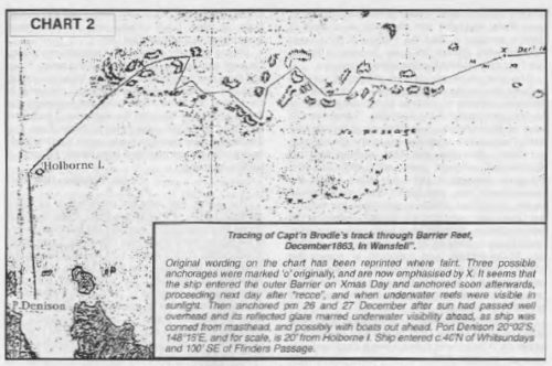
Original wording on the chart has been reprinted where faint. Three possible anchorages were marked `o’ originally, and are now emphasised by X. It seems that the ship entered the outer Barrier on Xmas Day and anchored soon afterwards, proceeding next day after “recce”, and when underwater reefs were visible in sunlight. Then anchored pm 26 and 27 December after sun had passed well overhead and its reflected glare marred underwater visibility ahead, as ship was conned from masthead, and possibly with boats out ahead. Port Denison 20°02’S, 148°16’E, and for scale, is 20′ from Holborne I. Ship entered c.40’N of Whitsundays and 100′ SE of Flinders Passage
Tracing of Capt’n Brodie’s Track through Barrier Reef Dec 1863 in Wansfell (chart 2). It bears a Hydrographic Office date stamp of October 14 (?) 1867. A signature below this is that of `G. P. Heath’ who was Portmaster, Brisbane at the time and for many years responsible for navigation on the Queensland coast and the above caption appears to be in his hand. It is apparent that Heath obtained his copy from the Admiralty, perhaps even the original, and Bowen copied it much later when the document was in the State Archives.
The rough chart only covers the ship’s final passage through the myriad of reefs inside the Barrier and shows just how tortuous her track was. A date of December 1863 is clearly shown, so it is surprising that the Hydrographer dated the notes of her dangerous passage as 1864 on official charts, obviously receiving the information in that year. Besides the date the only wording is the place names of Port Denison and Holborne Island, plus a note of “No passage” south of the Wansfell’s track. The latter may indicate that ship’s boats reconnoitred ahead although this observation may have been made from the masthead. Three small circles spaced along the track, (now marked X), may denote anchorages and there are obviously three boat soundings near the first of these. The depths indicate that the ship was then inside the outer Barrier, if only just; the water outside being too deep to anchor. There is no sign of where the two groundings occurred but one could guess that one, perhaps, was where course was almost reversed after running perilously close to a reef ahead.